Automatic Translation

Saturday, June 30, 2018

Siena provincial trails, day 8: Bagno Vignoni - Pienza (14 km)


What I said yesterday is not true: there is actually more than one daily bus run to Bagno Vignoni. There are a couple of early morning runs, and I took the 7:00 bus to pick up the trail where I left off yesterday. In the mist... Low clouds covered the town of Bagno Vignoni, deserted at that hour except for a few joggers, but by the time I had climbed the steep rise to Vignoni Alto, up above, the mist was burning off and the view from the southern gateway to the village was amazing!


Monte Amiata seen from Vignoni
I followed the route of the Via Francigena from Bagno Vignoni to San Quirico, and discovered something I hadn't noticed when walking to Rome: the route is also marked in the opposite direction, with the yellow arrow and pilgrim symbol, for Santiago! 


I only crossed paths with a couple of pilgrims, though, and saw one more getting off to a late start over cappuccino in San Quirico at 9:30. No time to be setting out for a day of hiking, in this season! By 10:00 the sun was quite hot. But I, too, stopped for a second breakfast in San Quirico, since I was in no hurry to get to Pienza, as the first bus back wasn't till 2:00. 

San Quirico: La Collegiata 
I haven't been posting many pictures of the towns I walk through on this blog, as I've been to them many times before, and besides, they are not really the subject of the blog, but the bits in between!

Here, however, are a few photos taken in beautiful San Quirico d'Orcia, a town that tends to be neglected by tourists but has a lot to offer: three beautiful churches, plenty of good restaurants and some of my favourite shops, as well as the famous Horti Leonini gardens. 


San Quirico: leaving town through the eastern gate

The eastern gate
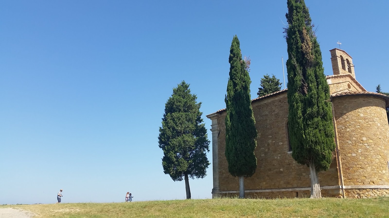
After leaving San Quirico, the trail follows the road toward Pienza for a short way, then turns off on a gravel road to Agriturismo La Buca, where it becomes a grassy path through the wheat fields and then a muddy path through the trees - ah, shade!!! But the cool, damp woods soon give way to more wheat fields and the beautiful curves for which the Val d'Orcia is famous. The trail passes right by the chapel of Vitaleta, surrounded by cypress trees, an iconic image captured in every season of the year on calendars and postcards sold all over Tuscany. From close up, however, it's harder to get a good picture than from far away! 


Capella di Vitaleta

Capella di Vitaleta


Pienza is coming closer! A trailmarker tells me there is only more hour to go, which is a good thing as it is becoming much too hot for walking, and there is not a breath of wind. From here I can look back and see how far I have come since I set out in the morning, in the valley between Rocca d'Orcia and the castle of Ripa d'Orcia, both clearly visible landmarks.


Approaching Pienza, I pass an old stone washing trough, something I had never had occasion to see before on my countless visits to the town - walking always leads to new discoveries, sometimes of things that are literally just around the corner from places you've been to many times before. And in fact the washing trough is only a few minutes' walk from the Pieve di Corsignano, the Romanesque church at the bottom of the hill where Pope Pius II, who later went on to order the construction of Pienza as an "ideal city", was baptised in 1405

The bit of the Pieve di Corsignano that I could see from my resting spot in the shade of a huge chestnut tree.
By this time I was too hot, tired and thirsty to get up and walk around the church taking more photos!
Anyway, it's the best bit.  (Except for the crypt, which used to be lots of fun until they had the *bright* idea of installing a light bulb and a light switch!)

One last effort and I was up the hill from Corsignano in the centre of Pienza, a Unesco World Heritage Site. It was rather shocking, after coming from the peace and quiet of the countryside, and after a week of hiking through practically deserted villages, to find that several events were going on in town, all at once, and none of which appeared to be particularly appreciative of the privilege of taking place in a World Heritage Site!

First, I came across some kind of a rally for fancy cars. 


There were lots more of these, parked all around the outside of the square I came to at the top of the hill coming up from Corsignano. I heard a low rumbling sound while enjoying my lunch at a bar, and sure enough by the time I left - they had all left too, speeding on to somewhere else in a great hurry. (I'm quite sure none of them even caught a glimpse of the old stone wash-trough!)

Then I came across a wedding, or rather, blundered into the video of it, passing right under the drone all hot and sweaty, with my hair out of place and my hiking boots and poles! 


It looked like a lovely wedding, with a very dignified father leaning on a cane as he walked his daughter up the isle preceded by a pair of very cute little bridesboys (or whatever you call the male equivalent of bridesmaids).

Then, when I was happily settled down at a bar table enjoying the view over the Val d'Orcia with my daily spritz on the table in front of me, a flock of these came pouring out of the bar:


I'm not really sure what they were, but they definitely must've been hot, out and about at noon in that sort of get-up!
Meanwhile, I recovered some of the liquids, and some of the salt, that I had sweated out on my way over the Crete (clay hills) with a spritz and a bowl of crisps, and looked out over the countryside I will be crossing next, towards Montichiello and Montepulciano, when I carry on with this route - in cooler weather!


Where I'll most likely be heading next!
Like many "touristy" towns, Pienza is actually quite a normal town once you get off the main tourist circuit and into the back streets. I decided to have lunch there, and bring some business to places that get overlooked by the weekend crowds parading up and down the main drag. For five euros I had a crepe filled with cheese, tomatoes and rucola, and another 2.50 bought me a delicious ice cream - chocolate and ginger apricot, a highly unusual flavour! Then it was time to go to the bus stop and home for a nice cold shower!

In the back streets of Pienza

In the back streets of Pienza

Bagno Vignoni - San Quirico - Pienza: 14 km


Friday, June 29, 2018

Siena provincial trail no. 2, day 7: Castelnuovo dell'Abate - Bagno Vignoni (13 km)


Temperatures are beginning to rise but are still bearable for hiking in the morning, so I picked up provincial trail no. 2 where I left off the other day, in Castelnuovo dell'Abate. On this leg, it overlaps with provincial trail no. 6, which then heads off across the Val d'Orcia towards Pienza and Montepulciano.


Once again there were hot-air balloons flying over - three of them this time! - when I walked down to the bus stop. 


After getting off the bus at the junction in Montalcino I walked across the roundabout to the road to Sant'Antimo, where it was easy to get a ride to Castelnuovo dell'Abate. The beautiful bar with the view of Monte Amiata was unfortunately not yet open for cappuccino, so I headed off uphill on a gravel road with beautiful views back towards Sant'Antimo. This part of the trail was entirely in the sun, but luckily it was still early in the morning, and by the time the sun was growing hot, the trail had dipped into a valley and among the trees down by the Orcia River. 

Castelnuovo dell'Abate and the 12th century Abbey of Sant'Antimo

Trail no. 2 heads off towards Monte Amiata (in the distance).
But on this section, it overlaps with trail no. 6 to Pienza and Montepulciano

Now I know what to do with the next pair of hiking boots that gives up the ghost!

View of Monte Amiata, the extinct volcano responsible for all the hot springs in the area

The castle of Ripa d'Orcia

My guidebook said this hike was "long and challenging" and gave an estimated time of five and a half hours, but I realised that this is a guidebook for wimps, because although there were a few ups and downs along the way, in only three hours I was in Bagno Vignoni soaking my feet in the hotsprings! Despite having to backtrack after taking a wrong turn that would have taken me straight to the village without stopping for a soak in the free open-air spa at the bottom of the hill. 

Bagno Vignoni: the baths at the bottom of the hill


After taking a refreshing dip and a warm shower where the water splashes off the cliff, I dressed again and climbed to the village at the top of the hill for a spritz in the bar by the pool that forms the centre of the town. Here I made friends with a lovely couple from northern England who holiday in Bagno Vignoni every year. It's easy to make friends when you are walking - people get curious when they see your hiking boots, sticks and maps and strike up a conversation. If you have a big backpack and are obviously walking a long-distance route, that makes you even more interesting! A woman walked by the bar who was clearly on her way to Rome - the Via Francigena also goes through Bagno Vignoni. 

After my spritz and chat at the bar I moved on to the Parco dei Mulini, a cross between a park and an archaeological site where there used to be a tower containing a mill operated by the power of the water from the hot springs, and a building containing hot showers - rare in the 18th century! - until the complex was destroyed by earthquake. It was recently uncovered and made into a park, with an amazing view and a bench in the shade - the perfect place to eat my lunch and spend the rest of my time until the town's one daily bus came in! 

Bagno Vignoni: the town centre, with baths in place of the usual piazza!
Unfortunately bathing is no longer allowed here, but there are lots of lovely restaurants and bars around the outside of the pool

Another hike successfully concluded with a Spritz!


Tuesday, June 26, 2018

Siena provincial trail no. 2, day 6: Montalcino - Castelnuovo dell'Abate (12 km)


Montalcino at 8 am on a Tuesday is quite a contrast to Montalcino on a Sunday afternoon when the Bersaglieri are having their annual celebration in town. But I didn't hang around too long enjoying the peace and quiet of the empty streets; I headed out past the fortress (still locked up) and onto the road toward Grosseto to find the start of the trail to Sant'Antimo and Castelnuovo dell'Abate.


The first 3.5 km of the trail, between Montalcino and Ragnaie, takes you into the woods that were historically the town's primary resource. It may be hard to believe now, but Montalcino was once a very poor village with an economy based on wood, and specifically charcoal-burning: the men of the town used to spend weeks in the forest, cutting down trees, stacking them just the right way and slowly burning them to produce charcoal for fuel. As you might guess, this was a lot less profitable than making Brunello! 

A reminder of what Montalcino used to be all about

Once the trail crosses over the paved road to Sant'Antimo, the character of the country changes radically, from woodland to open farmland and vineyards, opening up to the panorama of the Val d'Orcia and Monte Amiata in the distance.


Then you turn a corner and suddenly you are at the Abbey of Sant'Antimo - coming upon it from the back, and from above, so you don't see it until you are almost there!


After a brief rest in the shade of one of the ancient olive trees outside the Abbey, I skirted the abbey grounds and continued uphill to the charming village of Castelnuovo dell'Abate.


The perfect place to enjoy a cold drink and a snack with a view while waiting for the bus back to home base!